Mt. Upton, Today and Yesterday » Aerial view of Mount Upton

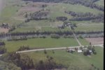
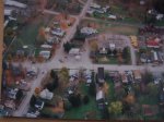
Aerial view of Mount Upton showing the Agway buildings and the school ball fields taken May 17, 1987 from a plane ride that I took at the Sidney airport fly in breakfast.

Batterson Bridge, Ohara Farm looking to the east, the road on the top is the back side of the river. Notice the river to the left of bricge, the shallow portion use to be where they had eel racks. Mt. Upton, New York

Leave a comment

Enter your email address to subscribe to this blog and receive notifications of new posts by email.

Join 100 other subscribers